Sunday, May 22, 2016
weekly reflection #3
This past week has been a whorl wind of a week, it has gone by so fast. I have accomplished a lot too, I have made two of my formats for my maps, since I will be printing out 4 or 5 total different formats. I will have trail maps that will be take away maps on 8.5x11 pieces of paper which will include the trails and wetlands. I will also have 11x17 inch pieces of paper to show the different layering options a person can have. I have enjoyed making the formats for the maps, and have been looking forward to printing my largest 3x4 foot maps. The 3x4 maps will be hung in ECO as decorations then I will keep one and Dave will have one as well. Everything has gone as excepted But I do worry about using FedEx to print some of my maps. I have benefited because I have learned the process of formatting maps so they make the most sense to the reader. This achieves my goal because I only have to format a few more sizes and then print them all.
Thursday, May 19, 2016
Week3 Day4-5
A lot of progressive has been made, I have been able to print out two copies of my map and handed one in two Dave. I have started thinking about how I will want to present my map during the show. I am going try to use the program in the meeting house and show how the different layers work with in the program. I will have two or three 3x4 foot maps then smaller 11x17 in maps with different layers showing, then final 8.5x11 trail maps. I will need to start making setting up then legend and title for each size of paper. I also have had my last meeting with Lynn Cox and I showed her the print map I got from Development. I will need to go to FedEx copy center to get the large 3x4 maps.


Tuesday, May 17, 2016
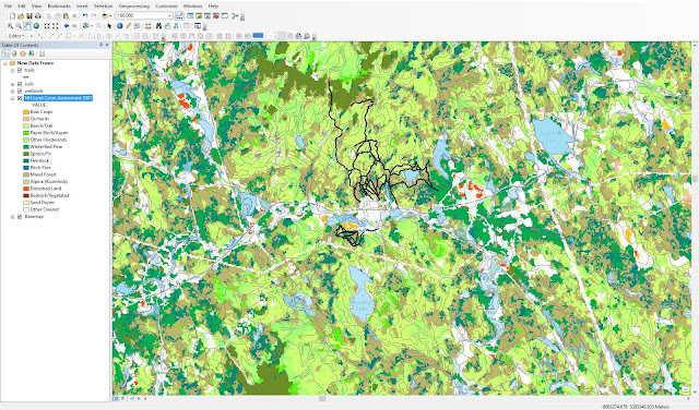
week:3 day:2
I was able to get a lot done today. Dave came over to check out the map and has okay it, also Scott Allenby said I could have a active map or could a link to my map under the woodlands page. I have started to work out on the layout of the map and how I am going to print it. I know that the largest map is going to be either 4x4 or 4x3 with a matte lamination that can be written on with dry erase makers. The problem I am having know is trying to get my focus area only to the Proctor Academy not the town of andover. I can zoom in on the map but it will zoom in on the town as a whole not just to PA.
Monday, May 16, 2016
Week3 day1
Today was interesting, Chris the guy from UNH did a huge favor for me when I met him on Friday. He was able to cut down one of my data files only to the town of Andover. However I struggled getting it into my map. Most of my hours today I was spent emailing and trying to trouble shoot it. I almost gave but I decided to talk to Seth and he suggested that I copy and paste the FTP server address into my computers search bar under "This PC". After I got that all settled I started work on making it look good but also that all the layers corporate together. I am trying to cut another piece of data so it does not have to load the entire state data. The time it takes to load is enough time that I can get distracted and move off from working on my map.
Sunday, May 15, 2016
Week 2 reflection
This week has had a lot of ups and downs, I had the opportunity to learn from each one. I learned that asking for help is okay and sometimes it is going to make your product overall better. Also going to an expert in the field you are studying is also a great idea. With all the frustrations I still enjoy what I am doing. I was asked to do this so Dave Pilla will have a current up to date map of all the important information he needs to mange the land. When I asked Sydney for help I knew she had friends everywhere in the tech world but I did not know the extent of it. I was pleasantly surprise with the results of calling in a favor. The expert I UNH was so helpful and friendly, I did not know what to expect going into it. I have made great progress( shown In the pictures below). I have to make the map look presentable and readable for all party's but especially for Dave. I also need to find a place to print my maps and laminate them as well.


Friday, May 13, 2016
W:2 Day:5
Oh what I day, over three hours in the car, A stop at UNH and then ending it with a scoop of ice cream from Johnsons. Today really could not have been better in terms of my senior project. I met with a man name Chris who works at GRANIT, he showed me what he has worked on and started to help me make my map presentable. Since all my data is now view able I can start to work on it being presentable. Since one of my files is so large and it takes my computer along time to reload everything when ever I move the map around, I was able with the help from Chris to get data from only the town of andover instead of the whole state. What Chris is working on right now is flood plane maps for towns but all for FEMA and insurance companies. Today was total worth the time I spent in the car. I can not wait to start making my map look professional.
Thursday, May 12, 2016
W:2 Day:4
Today was Amazing, I got so much accomplished to day. First I got a meeting with Chris at UNH GRANIT tomorrow afternoon. The original plan was for next week but he was able to fit me in his day, with his busy scheduled. I am going go into the meeting with my questions planned out, so I can maximize the efficient of the meeting. Hopeful I will be able to make a connection out of the meeting which could come in handy one day. Lastly I got the last piece of data I have been struggling with the past few weeks view able. I had to call in a favor from Sydney Lake to use one of her friends who is familiar with trouble shooting all kinds of tech problems. With out talking with Sydney I would still be struggling with getting that data view able. The problem was once I had the files downloaded I need to save it in a certain way to gain access to the actual data. The next couple days will be sent making sure the map can be viewed easily by everyone.
Subscribe to:
Posts (Atom)